Next Launch
Total Students
2,609
Total Launches
683
Eggs Survived
418 61.2%
Rockets Survived
536 78.5%
Dec. 1, 2017
Snowy Worlds Beyond Earth
by Linda Hermans-Killiam
There are many places on Earth where it snows, but did you know it snows on other worlds, too? Here are just a few of the places where you might find snow beyond Earth:
Mars
The north pole and south pole of Mars have ice caps that grow and shrink with the seasons. These ice caps are made mainly of water ice--the same kind of ice you'd find on Earth. However, the snow that falls there is made of carbon dioxide--the same ingredient used to make dry ice here on Earth. Carbon dioxide is in the Martian atmosphere and it freezes and falls to the surface of the planet as snow. In 2017, NASA's Mars Reconnaissance Orbiter took photos of the sand dunes around Mars' north pole. The slopes of these dunes were covered with carbon dioxide snow and ice.A Moon of Jupiter: Io
There are dozens of moons that orbit Jupiter and one of them, called Io, has snowflakes made out of sulfur. In 2001, NASA's Galileo spacecraft detected these sulfur snowflakes just above Io's south pole. The sulfur shoots into space from a volcano on Io's surface. In space, the sulfur quickly freezes to form snowflakes that fall back down to the surface.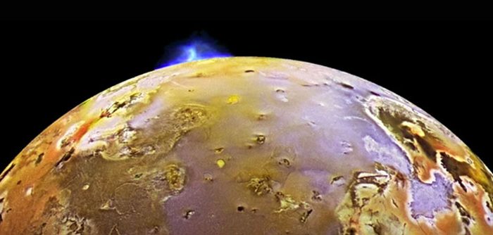
A Moon of Saturn: Enceladus
Saturn's moon, Enceladus, has geysers that shoot water vapor out into space. There it freezes and falls back to the surface as snow. Some of the ice also escapes Enceladus to become part of Saturn's rings. The water vapor comes from a heated ocean which lies beneath the moon's icy surface. (Jupiter's moon Europa is also an icy world with a liquid ocean below the frozen surface.) All of this ice and snow make Enceladus one of the brightest objects in our solar system.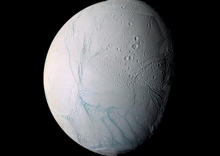
A Moon of Neptune: Triton
Neptune's largest moon is Triton. It has the coldest surface known in our solar system. Triton's atmosphere is made up mainly of nitrogen. This nitrogen freezes onto its surface covering Triton with ice made of frozen nitrogen. Triton also has geysers like Enceladus, though they are smaller and made of nitrogen rather than water.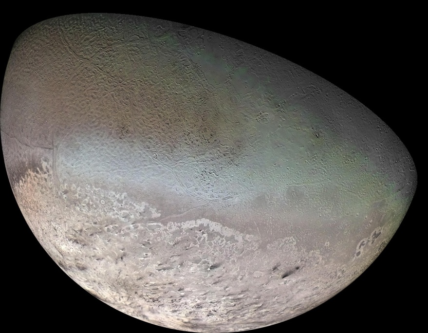
Pluto
Farther out in our solar system lies the dwarf planet Pluto. In 2016, scientists on the New Horizons mission discovered a mountain chain on Pluto where the mountains were capped with methane snow and ice.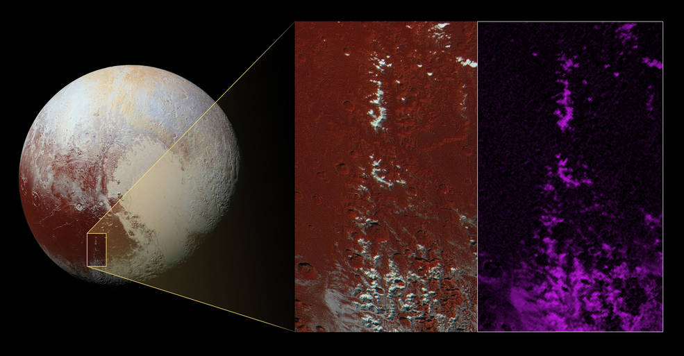
Beyond Our Solar System
There might even be snow far outside our solar system! Kepler-13Ab is a hot, giant planet 1,730 light years from Earth. It's nine times more massive than Jupiter and it orbits very close to its star. The Hubble Space Telescope detected evidence of titanium oxide--the mineral used in sunscreen--in this planet's upper atmosphere. On the cooler side of Kepler-13Ab that faces away from its host star, the planet's strong gravity might cause the titanium oxide to fall down as "snow."
Want to learn more about weather on other planets? Check out NASA Space Place: https://spaceplace.nasa.gov/planet-weather
This article is provided by NASA Space Place. With articles, activities, crafts, games, and lesson plans, NASA Space Place encourages everyone to get excited about science and technology. Visit spaceplace.nasa.gov to explore space and Earth science!
This article was provided by the Jet Propulsion Laboratory, California Institute of Technology, under a contract with the National Aeronautics and Space Administration.
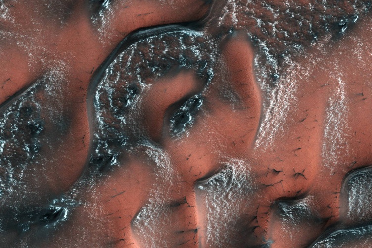 NASA's Mars Reconnaissance Orbiter captured this image of carbon dioxide snow covering dunes on Mars. Credit: NASA/JPL/University of Arizona
Jan. 1, 2018
Sixty Years of Observing Our Earth
by Teagan Wall
Satellites are a part of our everyday life. We use global positioning system (GPS) satellites to help us find directions. Satellite television and telephones bring us entertainment, and they connect people all over the world. Weather satellites help us create forecasts, and if there's a disaster-such as a hurricane or a large fire-they can help track what's happening. Then, communication satellites can help us warn people in harm's way.
There are many different types of satellites. Some are smaller than a shoebox, while others are bigger than a school bus. In all, there are more than 1,000 satellites orbiting Earth. With that many always around, it can be easy to take them for granted. However, we haven't always had these helpful eyes in the sky.
The United States launched its first satellite on Jan. 31, 1958. It was called Explorer 1, and it weighed in at only about 30 pounds. This little satellite carried America's first scientific instruments into space: temperature sensors, a microphone, radiation detectors and more.
Explorer 1 sent back data for four months, but remained in orbit for more than 10 years. This small, relatively simple satellite kicked off the American space age. Now, just 60 years later, we depend on satellites every day. Through these satellites, scientists have learned all sorts of things about our planet.
For example, we can now use satellites to measure the height of the land and sea with instruments called altimeters. Altimeters bounce a microwave or laser pulse off Earth and measure how long it takes to come back. Since the speed of light is known very accurately, scientists can use that measurement to calculate the height of a mountain, for example, or the changing levels of Earth's seas.
Satellites also help us to study Earth's atmosphere. The atmosphere is made up of layers of gases that surround Earth. Before satellites, we had very little information about these layers. However, with satellites' view from space, NASA scientists can study how the atmosphere's layers interact with light. This tells us which gases are in the air and how much of each gas can be found in the atmosphere. Satellites also help us learn about the clouds and small particles in the atmosphere, too.
When there's an earthquake, we can use radar in satellites to figure out how much Earth has moved during a quake. In fact, satellites allow NASA scientists to observe all kinds of changes in Earth over months, years or even decades.
Satellites have also allowed us-for the first time in civilization-to have pictures of our home planet from space. Earth is big, so to take a picture of the whole thing, you need to be far away. Apollo 17 astronauts took the first photo of the whole Earth in 1972. Today, we're able to capture new pictures of our planet many times every day.
Today, many satellites are buzzing around Earth, and each one plays an important part in how we understand our planet and live life here. These satellite explorers are possible because of what we learned from our first voyage into space with Explorer 1-and the decades of hard work and scientific advances since then.
To learn more about satellites, including where they go when they die, check out NASA Space Place: https://spaceplace.nasa.gov/spacecraft-graveyard
This article is provided by NASA Space Place. With articles, activities, crafts, games, and lesson plans, NASA Space Place encourages everyone to get excited about science and technology. Visit spaceplace.nasa.gov to explore space and Earth science!
This article was provided by the Jet Propulsion Laboratory, California Institute of Technology, under a contract with the National Aeronautics and Space Administration.
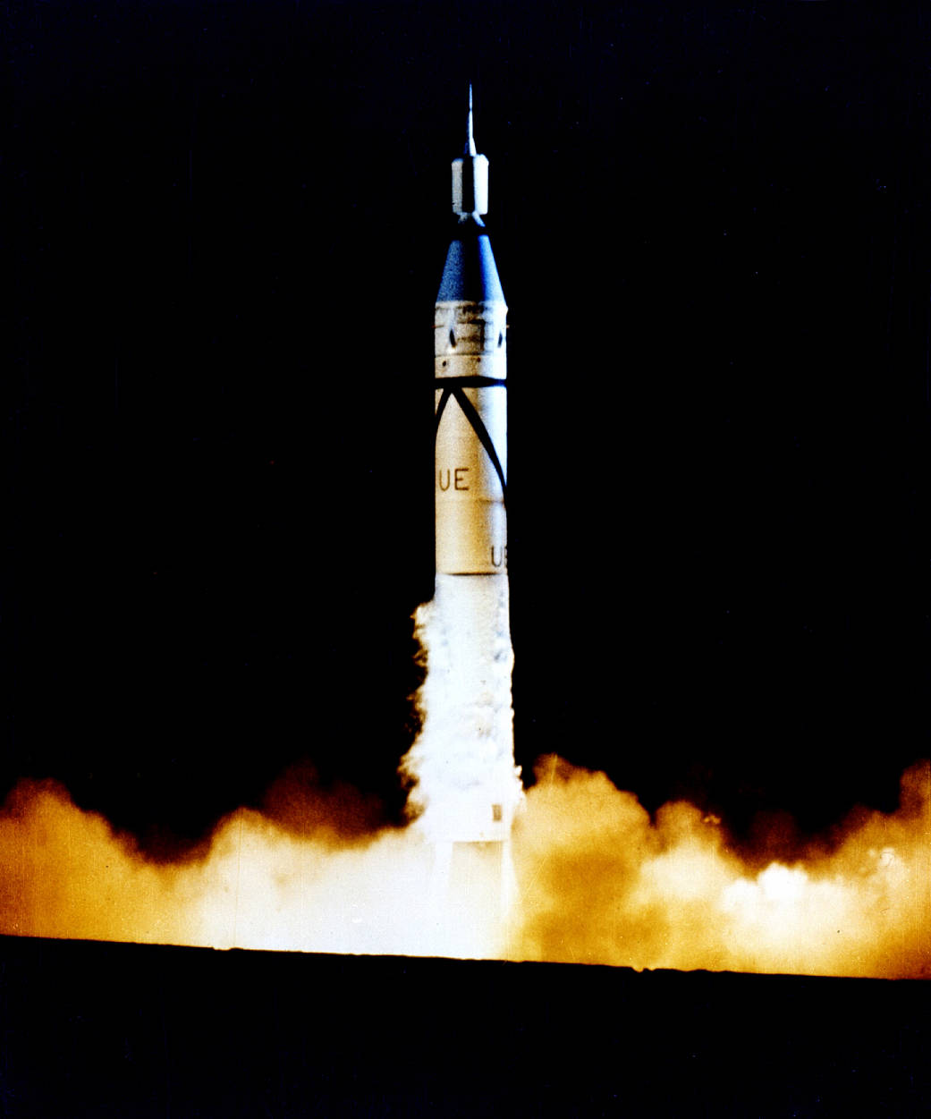 This photo shows the launch of Explorer 1 from Cape Canaveral, Fla., on Jan. 31, 1958. Explorer 1 is the small section on top of the large Jupiter-C rocket that blasted it into orbit. With the launch of Explorer 1, the United States officially entered the space age. Image credit: NASA
Feb. 1, 2018
What is the Ionoshpere?
by Linda Hermans-Killiam
High above Earth is a very active part of our upper atmosphere called the ionosphere. The ionosphere gets its name from ions--tiny charged particles that blow around in this layer of the atmosphere.
How did all those ions get there? They were made by energy from the Sun!
Everything in the universe that takes up space is made up of matter, and matter is made of tiny particles called atoms. At the ionosphere, atoms from the Earth's atmosphere meet up with energy from the Sun. This energy, called radiation, strips away parts of the atom. What's left is a positively or negatively charged atom, called an ion.
The ionosphere is filled with ions. These particles move about in a giant wind. However, conditions in the ionosphere change all the time. Earth's seasons and weather can cause changes in the ionosphere, as well as radiation and particles from the Sun--called space weather.
These changes in the ionosphere can cause problems for humans. For example, they can interfere with radio signals between Earth and satellites. This could make it difficult to use many of the tools we take for granted here on Earth, such as GPS. Radio signals also allow us to communicate with astronauts on board the International Space Station, which orbits Earth within the ionosphere. Learning more about this region of our atmosphere may help us improve forecasts about when these radio signals could be distorted and help keep humans safe.
In 2018, NASA has plans to launch two missions that will work together to study the ionosphere. NASA's GOLD (Global-scale Observations of the Limb and Disk) mission launched in January 2018. GOLD will orbit 22,000 miles above Earth. From way up there, it will be able to create a map of the ionosphere over the Americas every half hour. It will measure the temperature and makeup of gases in the ionosphere. GOLD will also study bubbles of charged gas that are known to cause communication problems.
A second NASA mission, called ICON, short for Ionospheric Connection Explorer, will launch later in 2018. It will be placed in an orbit just 350 miles above Earth--through the ionosphere. This means it will have a close-up view of the upper atmosphere to pair with GOLD's wider view. ICON will study the forces that shape this part of the upper atmosphere.
Both missions will study how the ionosphere is affected by Earth and space weather. Together, they will give us better observations of this part of our atmosphere than we have ever had before.
To learn more about the ionosphere, check out NASA Space Place: https://spaceplace.nasa.gov/ionosphere
This article is provided by NASA Space Place. With articles, activities, crafts, games, and lesson plans, NASA Space Place encourages everyone to get excited about science and technology. Visit spaceplace.nasa.gov to explore space and Earth science!
This article was provided by the Jet Propulsion Laboratory, California Institute of Technology, under a contract with the National Aeronautics and Space Administration.
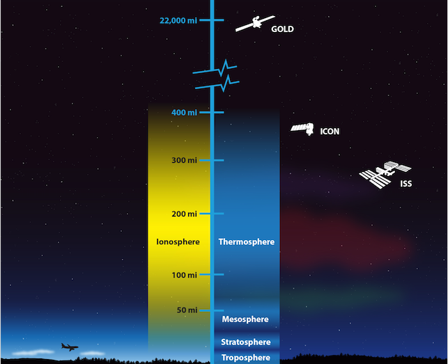 This illustration shows the layers of Earth's atmosphere. NASA's GOLD and ICON missions will work together to study the ionosphere. Credit: NASA's Goddard Space Flight Center/Duberstein (modified)
March 1, 2018
Measuring the Movement of Water on Earth
by Teagan Wall
As far as we know, water is essential for every form of life. On our planet, we find water at every stage: liquid, solid (ice), and gas (steam and vapor). Our bodies are mostly water. We use it to drink, bathe, clean, grow crops, make energy, and more. With everything it does, measuring where the water on Earth is, and how it moves, is no easy task. NASA scientists have to get creative to study it all. One way they will measure where all that water is and how it moves, is by launching a set of spacecraft this spring called GRACE-FO. BODY
As far as we know, water is essential for every form of life. It's a simple molecule, and we know a lot about it. Water has two hydrogen atoms and one oxygen atom. It boils at 212° Fahrenheit (100° Celsius) and freezes at 32° Fahrenheit (0° Celsius). The Earth's surface is more than 70 percent covered in water.
On our planet, we find water at every stage: liquid, solid (ice), and gas (steam and vapor). Our bodies are mostly water. We use it to drink, bathe, clean, grow crops, make energy, and more. With everything it does, measuring where the water on Earth is, and how it moves, is no easy task.
The world's oceans, lakes, rivers and streams are water. However, there's also water frozen in the ice caps, glaciers, and icebergs. There's water held in the tiny spaces between rocks and soils deep underground. With so much water all over the planet--including some of it hidden where we can't see--NASA scientists have to get creative to study it all. One way that NASA will measure where all that water is and how it moves, is by launching a set of spacecraft this spring called GRACE-FO.
GRACE-FO stands for the "Gravity Recovery and Climate Experiment Follow-on." "Follow-on" means it's the second satellite mission like this--a follow-up to the original GRACE mission. GRACE-FO will use two satellites. One satellite will be about 137 miles (220 km) behind the other as they orbit the Earth. As the satellites move, the gravity of the Earth will pull on them.
Gravity isn't the same everywhere on Earth. Areas with more mass--like big mountains--have a stronger gravitational pull than areas with less mass. When the GRACE-FO satellites fly towards an area with stronger gravitational pull, the first satellite will be pulled a little faster. When the second GRACE-FO satellite reaches the stronger gravity area, it will be pulled faster, and catch up.
Scientists combine this distance between the two satellites with lots of other information to create a map of Earth's gravity field each month. The changes in that map will tell them how land and water move on our planet. For example, a melting glacier will have less water, and so less mass, as it melts. Less mass means less gravitational pull, so the GRACE-FO satellites will have less distance between them. That data can be used to help scientists figure out if the glacier is melting.
GRACE-FO will also be able to look at how Earth's overall weather changes from year to year. For example, the satellite can monitor certain regions to help us figure out how severe a drought is. These satellites will help us keep track of one of the most important things to all life on this planet: water.
You can learn more about our planet's most important molecule here: https://spaceplace.nasa.gov/water
This article is provided by NASA Space Place. With articles, activities, crafts, games, and lesson plans, NASA Space Place encourages everyone to get excited about science and technology. Visit spaceplace.nasa.gov to explore space and Earth science!
This article was provided by the Jet Propulsion Laboratory, California Institute of Technology, under a contract with the National Aeronautics and Space Administration.
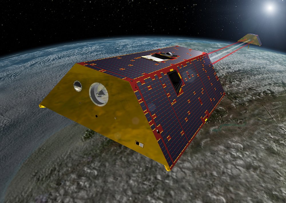 An artist's rendering of the twin GRACE-FO spacecraft in orbit around Earth. Credit: NASA