Next Launch
Total Students
2,609
Total Launches
683
Eggs Survived
418 61.2%
Rockets Survived
536 78.5%
Aug. 1, 2017
The 2017 Solar Eclipse Across America
by Teagan Wall
On August 21st, the sky will darken, the temperature will drop and all fifty United States will be able to see the Moon pass--at least partially--in front of the Sun. It's a solar eclipse!
A solar eclipse happens when the Moon passes between the Sun and Earth, casting its shadow on Earth. Sometimes the Moon only covers up part of the Sun. That is called a partial solar eclipse. When the Moon covers up the Sun completely, it's called a total solar eclipse. As our planet rotates, the Moon's shadow moves across Earth's surface. The path of the inner part of this shadow, where the Moon totally covers the Sun, is called the path of totality.
The path of totality on August 21 stretches from Oregon to South Carolina. If you happen to be in that path, you will be able to experience a total solar eclipse! If you're in any of the 50 United States during this time, you can see a partial solar eclipse.
No matter where you'll be for the eclipse, remember that SAFETY is very important. Never look at the Sun when any part of it is exposed, like during a partial eclipse! It can hurt your eyes very badly. If you want to view the eclipse, you can buy special eclipse glasses. Go the NASA 2017 Eclipse Safety website https://eclipse2017.nasa.gov/safety to learn more about what glasses to buy.
If you are in the path of the total eclipse, you may look directly at the eclipse only when the Moon has completely covered the Sun. This is called totality, and it lasts a very short time. You must be sure to put your eclipse glasses back on before the Sun peeks out from behind the Moon.
You won't be the only one watching this event! NASA scientists will use this eclipse to study our Sun. During a total solar eclipse, we can see the Sun's atmosphere, called the corona. Usually the Sun is so bright that we can't see the corona. However, when the Moon blocks out most of the Sun's light, we can get a glimpse of the corona.
The surface of the Sun is about 10,000 degrees Fahrenheit, but the corona is much hotter. It's about 2 million degrees Fahrenheit! The eclipse gives NASA researchers the chance to learn more about why the corona is so hot. In fact, while the eclipse will only last about two to three minutes in one place, scientists have found a way to have more time to study it.
NASA will use two research jets to chase the eclipse as it crosses the country. The jets will fly very high, and spend seven minutes in the shadow of the Moon. Researchers are using jets to help look for small explosions on the Sun, called nanoflares. These nanoflares may help to explain the corona's extreme heat.
Whether you're watching with eclipse glasses from the ground, or in a NASA jet from the sky, the 2017 eclipse should be quite a show! It's a fun reminder of our place in the solar system, and how much we still have to learn.
To learn about what eclipse glasses to buy and other eclipse safety guidelines, visit: https://eclipse2017.nasa.gov/safety
To learn more about solar eclipses, check out this NASA Space Place video: https://spaceplace.nasa.gov/eclipse-snap
This article is provided by NASA Space Place.
With articles, activities, crafts, games, and lesson plans, NASA Space Place encourages everyone to get excited about science and technology. Visit spaceplace.nasa.gov to explore space and Earth science!
This article was provided by the Jet Propulsion Laboratory, California Institute of Technology, under a contract with the National Aeronautics and Space Administration.
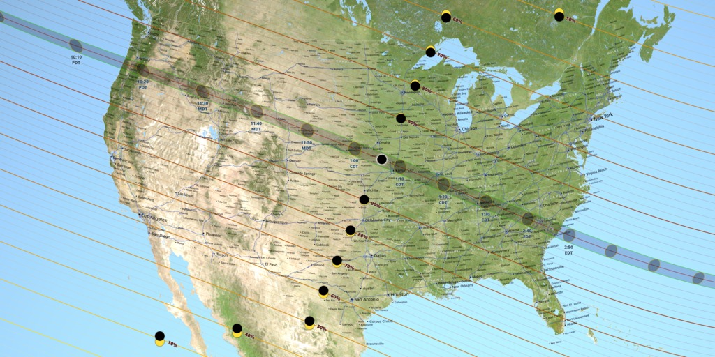 A map of the United States showing the path of totality for the August 21, 2017 total solar eclipse. Image credit: NASA's Scientific Visualization Studio
Sept. 1, 2017
Cassini Says Goodbye
by Teagan Wall
On September 15th, the Cassini spacecraft will have its final mission. It will dive into the planet Saturn, gathering information and sending it back to Earth for as long as possible. As it dives, it will burn up in the atmosphere, much like a meteor. Cassini's original mission was supposed to last four years, but it has now been orbiting Saturn for more than 13 years!
The spacecraft has seen and discovered so many things in that time. In 2010, Cassini saw a massive storm in Saturn's northern hemisphere. During this storm, scientists learned that Saturn's atmosphere has water vapor, which rose to the surface. Cassini also looked at the giant storm at Saturn's north pole. This storm is shaped like a hexagon. NASA used pictures and other data from Cassini to learn how the storm got its six-sided shape.
Cassini also looked at some of Saturn's moons, such as Titan and Enceladus. Titan is Saturn's largest moon. Cassini carried a lander to Titan. The lander, called Huygens, parachuted from Cassini down to the surface of the moon. It turns out, Titan is quite an exciting place! It has seas, rivers, lakes and rain. This means that in some ways, Titan's landscape looks a bit like Earth. However, its seas and rivers aren't made of water?they're made of a chemical called methane.
Cassini also helped us learn that Saturn's moon Enceladus is covered in ice. Underneath the ice is a giant liquid ocean that covers the whole moon. Tall geysers from this ocean spray out of cracks in the ice and into space, like a giant sneeze. Cassini flew through one of these geysers. We learned that the ocean is made of very salty water, along with some of the chemicals that living things need.
If there is life on Enceladus, NASA scientists don't want life from Earth getting mixed in. Tiny living things may have hitched a ride on Cassini when it left Earth. If these germs are still alive, and they land on Enceladus, they could grow and spread. We want to protect Enceladus, so that if we find life, we can be sure it didn't come from Earth. This idea is called planetary protection.
Scientists worry that when Cassini runs out of fuel, it could crash into Titan or Enceladus. So years ago, they came up with a plan to prevent that from happening. Cassini will complete its exploration by diving into Saturn?on purpose. The spacecraft will burn up and become part of the planet it explored. During its final plunge, Cassini will tell us more about Saturn's atmosphere, and protect the moons at the same time. What an exciting way to say goodbye!
To learn more about Saturn, check out NASA Space Place: https://spaceplace.nasa.gov/all-about-saturn
This article is provided by NASA Space Place. With articles, activities, crafts, games, and lesson plans, NASA Space Place encourages everyone to get excited about science and technology. Visit spaceplace.nasa.gov to explore space and Earth science!
This article was provided by the Jet Propulsion Laboratory, California Institute of Technology, under a contract with the National Aeronautics and Space Administration.
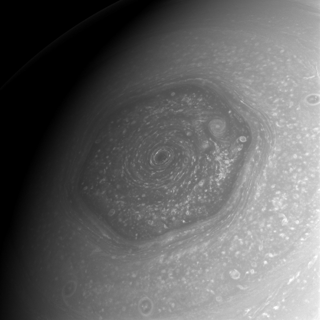 This image of the hexagonal storm on Saturn's north pole was taken by Cassini in 2013. Image credit: NASA/JPL-Caltech/Space Science Institute
Oct. 1, 2017
Spooky in Space: NASA Images for Halloween
by Linda Hermans-Killiam
Have you ever seen a cloud that looks sort of like a rabbit? Or maybe a rock formation that looks a bit like an elephant? Although you know that a cloud isn't really a giant rabbit in the sky, it's still fun to look for patterns in images from nature. Can you spot some familiar spooky sites in the space images below?
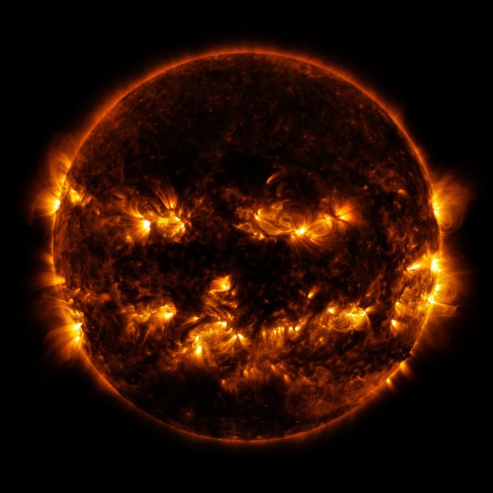
This might look like the grinning face of a jack-o'-lantern, but it's actually a picture of our Sun! In this image, taken by NASA's Solar Dynamics Observatory, the glowing eyes, nose and mouth are some of the Sun's active regions. These regions give off lots of light and energy. This causes them to appear brighter against the rest of the Sun. Active regions are constantly changing locations on the Sun. On the day this image was captured, they just happened to look like a face!
Credit: NASA/ESA/A. Simon (Goddard Space Flight Center)
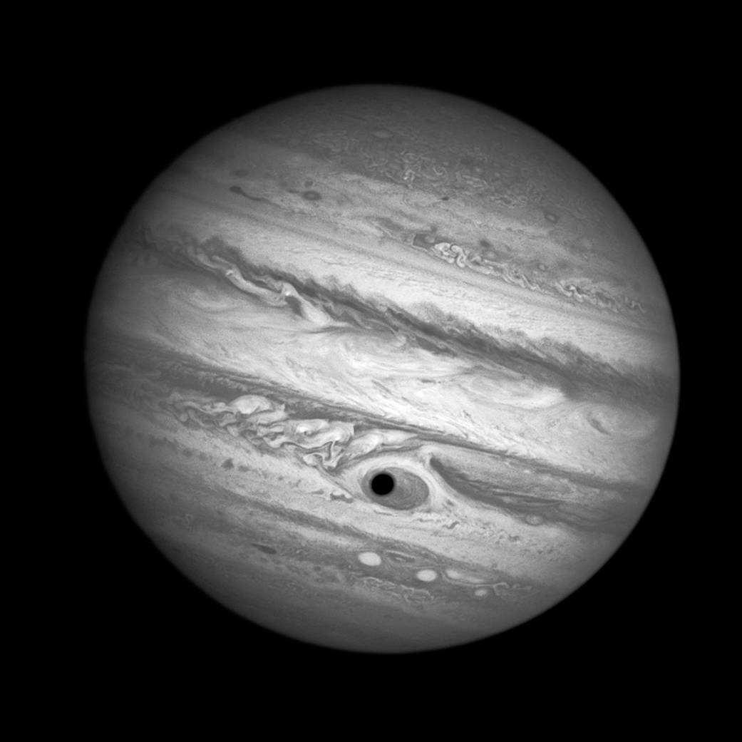
This is a Hubble Space Telescope image of Jupiter. Do you notice something that looks like a big eye peeking back at you? That's actually the shadow of Jupiter's moon Ganymede as it passed in front of the planet's Great Red Spot. Jupiter's Great Red Spot is a gigantic, oval shaped storm that is larger than Earth and is shrinking. It has been on Jupiter for several hundred years, and its winds can swirl up to 400 miles per hour!
Credit: NASA/JPL-Caltech
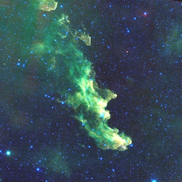
Can you see the profile of a witch in this image? This image, from NASA's Wide-Field Infrared Survey Explorer, shows the Witch Head nebula. The nebula is made up of clouds of dust heated by starlight. These dust clouds are where new stars are born. Here, the dust clouds happen to be in the shape of an open mouth, long nose and pointy chin.
Credit: NASA/JPL-Caltech/Univ. of Wisc.
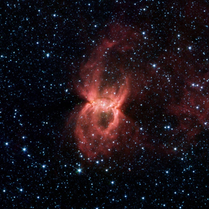
The Black Widow Nebula looks like a giant spider in space. It is a huge cloud of gas and dust containing massive young stars. Radiation and winds from these stars push the dust and gas around, creating a spider-like shape. This image is from NASA's Spitzer Space Telescope.
Credit: NASA/JPL-CALTECH/MSSS
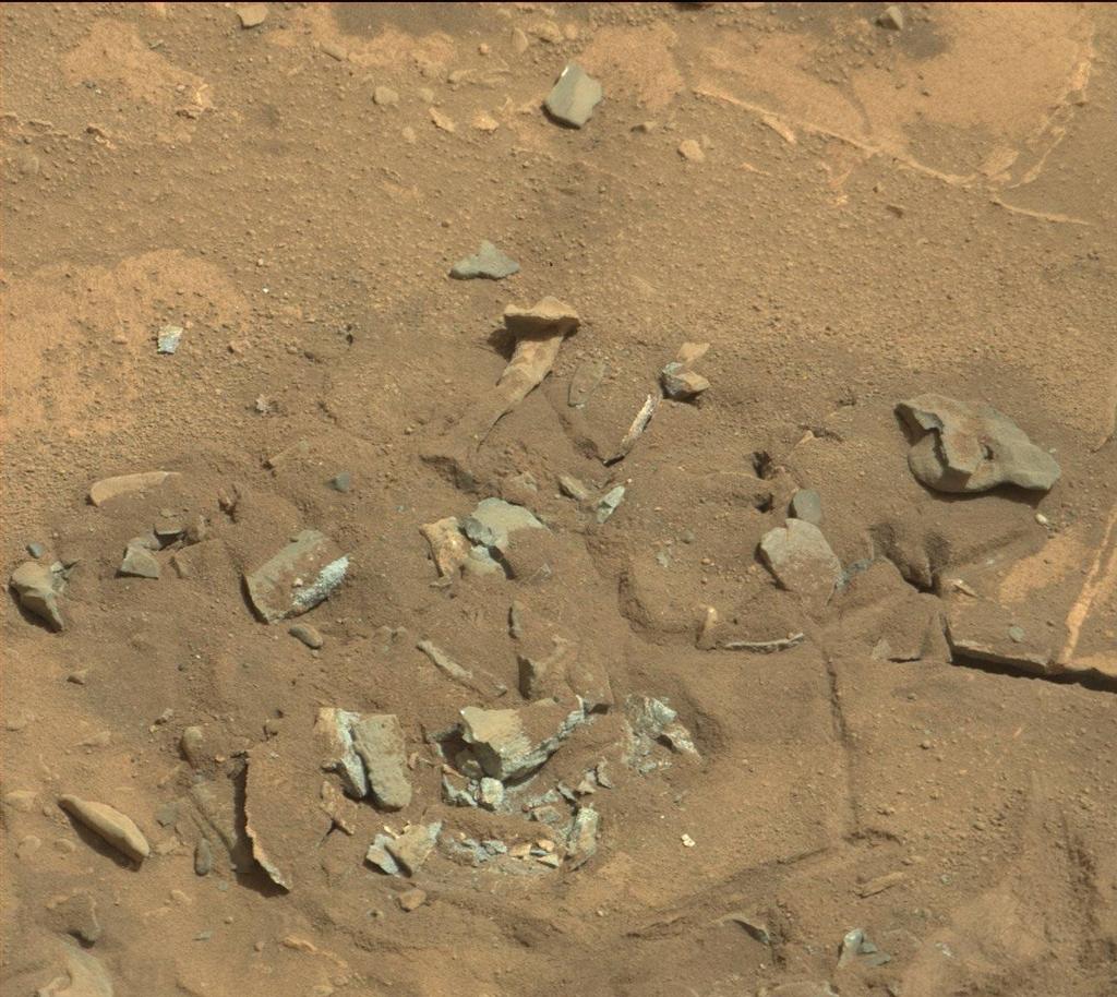
Did a skeleton lose one of its leg bones on Mars? Nope! It's just an image of a Martian rock. NASA's Curiosity rover captured this image. The rock was probably shaped to look this way over time by wind or water. If life ever existed on Mars, scientists expect that it would be small organisms called microbes. So, it isn't likely that we'll ever find a large fossil on Mars!
To learn some fun planet facts and make a planet mask, check out NASA Space Place: https://spaceplace.nasa.gov/planet-masks
This article is provided by NASA Space Place. With articles, activities, crafts, games, and lesson plans, NASA Space Place encourages everyone to get excited about science and technology. Visit spaceplace.nasa.gov to explore space and Earth science!
This article was provided by the Jet Propulsion Laboratory, California Institute of Technology, under a contract with the National Aeronautics and Space Administration.
 Credit: NASA/GSFC/SDO
Nov. 1, 2017
Studying Storms from the Sky
by Teagan Wall
The United States had a rough hurricane season this year. Scientists collect information before and during hurricanes to understand the storms and help people stay safe. However, collecting information during a violent storm is very difficult.
Hurricanes are constantly changing. This means that we need a lot of really precise data about the storm. It's pretty hard to learn about hurricanes while inside the storm, and instruments on the ground can be broken by high winds and flooding. One solution is to study hurricanes from above. NASA and NOAA can use satellites to keep an eye on storms that are difficult to study on the ground.
In Puerto Rico, Hurricane Maria was so strong that it knocked out radar before it even hit land. Radar can be used to predict a storm's path and intensity-and without radar, it is difficult to tell how intense a storm will be. Luckily, scientists were able to use information from a weather satellite called GOES-16, short for Geostationary Operational Environmental Satellite - 16.
The "G" in GOES-16 stands for geostationary. This means that the satellite is always above the same place on the Earth, so during Hurricane Maria, it never lost sight of the storm. GOES-16's job as a weather satellite hasn't officially started yet, but it was collecting information and was able to help.
From 22,000 miles above Earth, GOES-16 watched Hurricane Maria, and kept scientists on the ground up to date. Knowing where a storm is-and what it's doing-can help keep people safe, and get help to the people that need it.
Hurricanes can also have a huge impact on the environment-even after they're gone. To learn about how Hurricane Irma affected the Florida coast, scientists used images from an environmental satellite called Suomi National Polar-orbiting Partnership, or Suomi-NPP. One of the instruments on this satellite, called VIIRS (Visible Infrared Imaging Radiometer Suite), took pictures of Florida before and after the Hurricane.
Hurricane Irma was so big and powerful, that it moved massive amounts of dirt, water and pollution. The information captured by VIIRS can tell scientists how and where these particles are moving in the water. This can help with recovery efforts, and help us design better ways to prepare for hurricanes in the future.
By using satellites like GOES-16 and Suomi-NPP to observe severe storms, researchers and experts stay up to date in a safe and fast way. The more we know about hurricanes, the more effectively we can protect people and the environment from them in the future.
To learn more about hurricanes, check out NASA Space Place: https://spaceplace.nasa.gov/hurricanes/
This article is provided by NASA Space Place. With articles, activities, crafts, games, and lesson plans, NASA Space Place encourages everyone to get excited about science and technology. Visit spaceplace.nasa.gov to explore space and Earth science!
This article was provided by the Jet Propulsion Laboratory, California Institute of Technology, under a contract with the National Aeronautics and Space Administration.
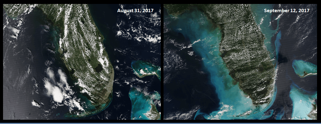 These images of Florida and the Bahamas were captured by a satellite called Suomi-NPP. The image on the left was taken before Hurricane Irma and the image on the right was taken after the hurricane. The light color along the coast is dirt, sand and garbage brought up by the storm. Image credit: NASA/NOAA