Next Launch
Total Students
2,609
Total Launches
683
Eggs Survived
418 61.2%
Rockets Survived
536 78.5%
Dec. 1, 2013
The Big Picture: GOES-R and the Advanced Baseline Imager
by Kieran Mulvaney
The ability to watch the development of storm systems - ideally in real time, or as close as possible - has been an invaluable benefit of the Geostationary Operational Environmental Satellites (GOES) system, now entering its fortieth year in service. But it has sometimes come with a trade-off: when the equipment on the satellite is focused on such storms, it isn't always able to monitor weather elsewhere.
"Right now, we have this kind of conflict," explains Tim Schmit of NOAA's National Environmental Satellite, Data, and Information Service (NESDIS). "Should we look at the broad scale, or look at the storm scale?" That should change with the upcoming launch of the first of the latest generation of GOES satellites, dubbed the GOES-R series, which will carry aloft a piece of equipment called the Advanced Baseline Imager (ABI).
According to Schmit, who has been working on its development since 1999, the ABI will provide images more frequently, at greater resolution and across more spectral bands (16, compared to five on existing GOES satellites). Perhaps most excitingly, it will also allow simultaneous scanning of both the broader view and not one but two concurrent storm systems or other small-scale patterns, such as wildfires, over areas of 1000km x 1000km.
Although the spatial resolution will not be any greater in the smaller areas than in the wider field of view, the significantly greater temporal resolution on the smaller scale (providing one image a minute) will allow meteorologists to see weather events unfold almost as if they were watching a movie.
So, for example, the ABI could be pointed at an area of Oklahoma where conditions seem primed for the formation of tornadoes. "And now you start getting one-minute data, so you can see small-scale clouds form, the convergence and growth," says Schmit.
In August, Schmit and colleagues enjoyed a brief taste of how that might look when they turned on the GOES-14 satellite, which serves as an orbiting backup for the existing generation of satellites.
"We were allowed to do some experimental imaging with this one-minute imagery," Schmit explains. "So we were able to simulate the temporal component of what we will get with ABI when it's launched."
The result was some imagery of cloud formation that, while not of the same resolution as the upcoming ABI images, unfolded on the same time scale. You can compare the difference between it and the existing GOES-13 imagery here: http://cimss.ssec.wisc.edu/goes/blog/wp-content/uploads/2013/08/GOES1314_VIS_21AUG2013loop.gif
Learn more about the GOES-R series of satellites here: http://www.goes-r.gov.
Kids should be sure to check out a new online game that's all about ABI! It's as exciting as it is educational. Check it out at http://scijinks.gov/abi.
This article was provided by the Jet Propulsion Laboratory, California Institute of Technology, under a contract with the National Aeronautics and Space Administration.
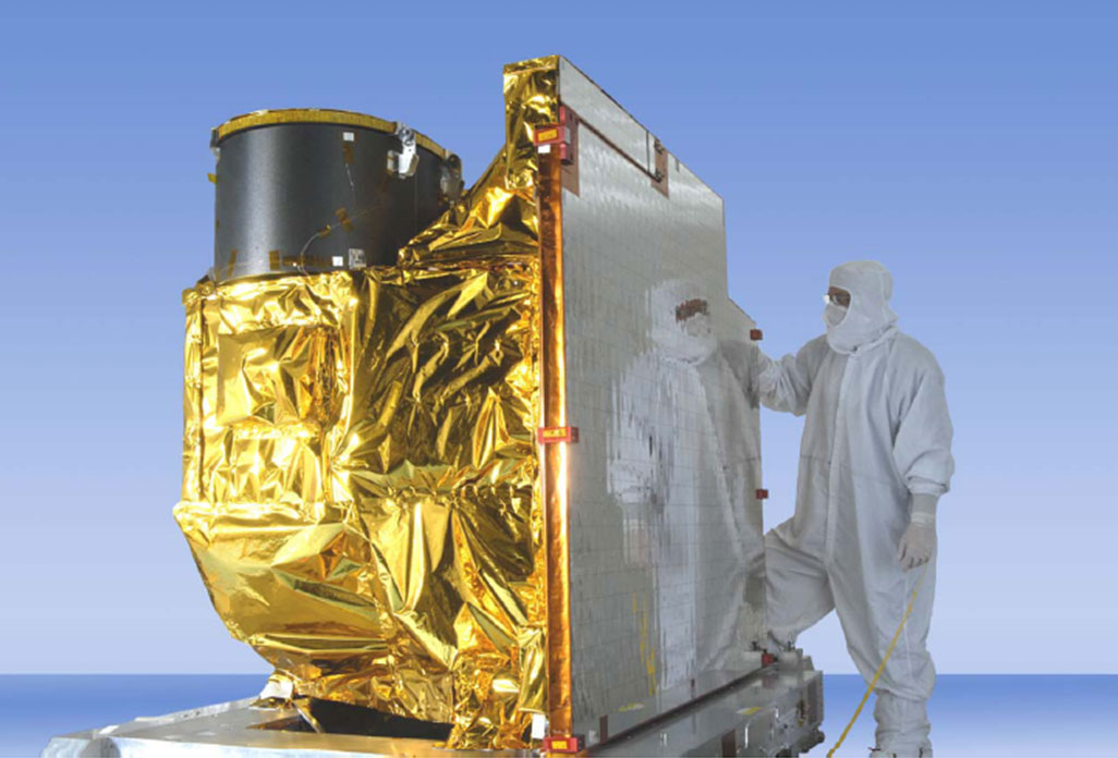 The Advanced Baseline Imager. Credit: NOAA/NASA.
Jan. 1, 2014
Surprising Young Stars in the Oldest Places in the Universe
by Dr. Ethan Siegel
Littered among the stars in our night sky are the famed deep-sky objects. These range from extended spiral and elliptical galaxies millions or even billions of light years away to the star clusters, nebulae, and stellar remnants strewn throughout our own galaxy. But there's an intermediate class of objects, too: the globular star clusters, self-contained clusters of stars found in spherically-distributed halos around each galaxy.
Back before there were any stars or galaxies in the universe, it was an expanding, cooling sea of matter and radiation containing regions where the matter was slightly more dense in some places than others. While gravity worked to pull more and more matter into these places, the pressure from radiation pushed back, preventing the gravitational collapse of gas clouds below a certain mass. In the young universe, this meant no clouds smaller than around a few hundred thousand times the mass of our Sun could collapse. This coincides with a globular cluster's typical mass, and their stars are some of the oldest in the universe!
These compact, spherical collections of stars are all less than 100 light-years in radius, but typically have around 100,000 stars inside them, making them nearly 100 times denser than our neighborhood of the Milky Way! The vast majority of globular clusters have extremely few heavy elements (heavier than helium), as little as 1% of what we find in our Sun. There's a good reason for this: our Sun is only 4.5 billion years old and has seen many generations of stars live-and-die, while globular clusters (and the stars inside of them) are often over 13 billion years old, or more than 90% the age of the universe! When you look inside one of these cosmic collections, you're looking at some of the oldest stellar swarms in the known universe.
Yet when you look at a high-resolution image of these relics from the early universe, you'll find a sprinkling of hot, massive, apparently young blue stars! Is there a stellar fountain of youth inside? Kind of! These massive stellar swarms are so dense -- especially towards the center -- that mergers, mass siphoning and collisions between stars are quite common. When two long-lived, low-mass stars interact in these ways, they produce a hotter, bluer star that will be much shorter lived, known as a blue straggler star. First discovered by Allan Sandage in 1953, these young-looking stars arise thanks to stellar cannibalism. So enjoy the brightest and bluest stars in these globular clusters, found right alongside the oldest known stars in the universe!
Learn about a recent globular cluster discovery here: http://www.nasa.gov/press/2013/september/hubble-uncovers-largest-known-group-of-star-clusters-clues-to-dark-matter.
Kids can learn more about how stars work by listening to The Space Place?s own Dr. Marc: http://spaceplace.nasa.gov/podcasts/en/#stars.
This article was provided by the Jet Propulsion Laboratory, California Institute of Technology, under a contract with the National Aeronautics and Space Administration.
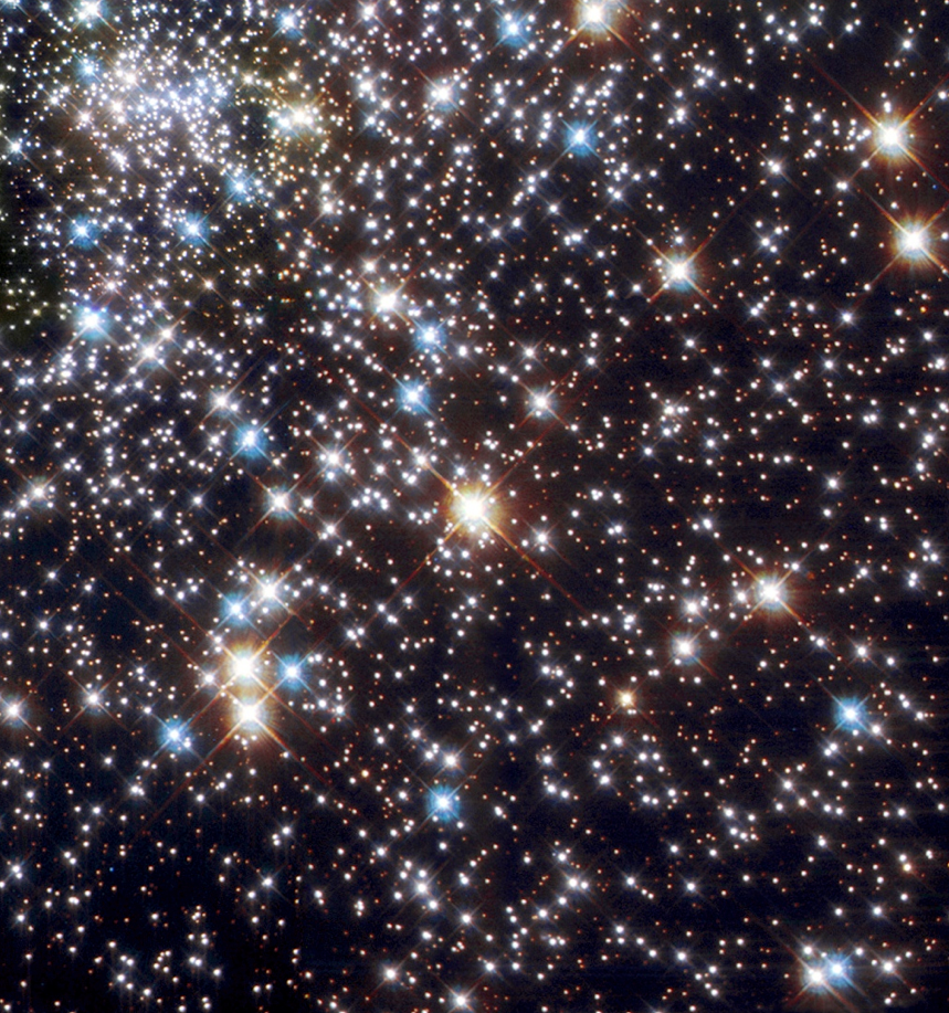 Globular Cluster NGC 6397. Credit: ESA & Francesco Ferraro (Bologna Astronomical Observatory) / NASA, Hubble Space Telescope, WFPC2.
Feb. 1, 2014
A Two-Toned Wonder from the Saturnian Outskirts
by Dr. Ethan Siegel
Although Saturn has been known as long as humans have been watching the night sky, it's only since the invention of the telescope that we've learned about the rings and moons of this giant, gaseous world. You might know that the largest of Saturn's moons is Titan, the second largest moon in the entire Solar System, discovered by Christiaan Huygens in 1655. It was just 16 years later, in 1671, that Giovanni Cassini (for whom the famed division in Saturn's rings - and the NASA mission now in orbit there - is named) discovered the second of Saturn's moons: Iapetus. Unlike Titan, Iapetus could only be seen when it was on the west side of Saturn, leading Cassini to correctly conclude that not only was Iapetus tidally locked to Saturn, but that its trailing hemisphere was intrinsically brighter than its darker, leading hemisphere. This has very much been confirmed in modern times!
In fact, the darkness of the leading side is comparable to coal, while the rest of Iapetus is as white as thick sea ice. Iapetus is the most distant of all of Saturn's large moons, with an average orbital distance of 3.5 million km, but the culprit of the mysterious dark side is four times as distant: Saturn's remote, captured moon, the dark, heavily cratered Phoebe!
Orbiting Saturn in retrograde, or the opposite direction to Saturn's rotation and most of its other Moons, Phoebe most probably originated in the Kuiper Belt, migrating inwards and eventually succumbing to gravitational capture. Due to its orbit, Phoebe is constantly bombarded by micrometeoroid-sized (and larger) objects, responsible for not only its dented and cavity-riddled surface, but also for a huge, diffuse ring of dust grains spanning quadrillions of cubic kilometers! The presence of the "Phoebe Ring" was only discovered in 2009, by NASA's infrared-sensitive Spitzer Space Telescope. As the Phoebe Ring's dust grains absorb and re-emit solar radiation, they spiral inwards towards Saturn, where they smash into Iapetus - orbiting in the opposite direction - like bugs on a highway windshield. Was the dark, leading edge of Iapetus due to it being plastered with material from Phoebe? Did those impacts erode the bright surface layer away, revealing a darker substrate?
In reality, the dark particles picked up by Iapetus aren't enough to explain the incredible brightness differences alone, but they absorb and retain just enough extra heat from the Sun during Iapetus' day to sublimate the ice around it, which resolidifies preferentially on the trailing side, lightening it even further. So it's not just a thin, dark layer from an alien moon that turns Iapetus dark; it's the fact that surface ice sublimates and can no longer reform atop the leading side that darkens it so severely over time. And that story - only confirmed by observations in the last few years - is the reason for the one-of-a-kind appearance of Saturn's incredible two-toned moon, Iapetus!
Learn more about Iapetus here: https://solarsystem.nasa.gov/moons/saturn-moons/iapetus/in-depth/.
Kids can learn more about Saturn?s rings at NASA?s Space Place: http://spaceplace.nasa.gov/saturn-rings.
This article was provided by the Jet Propulsion Laboratory, California Institute of Technology, under a contract with the National Aeronautics and Space Administration.
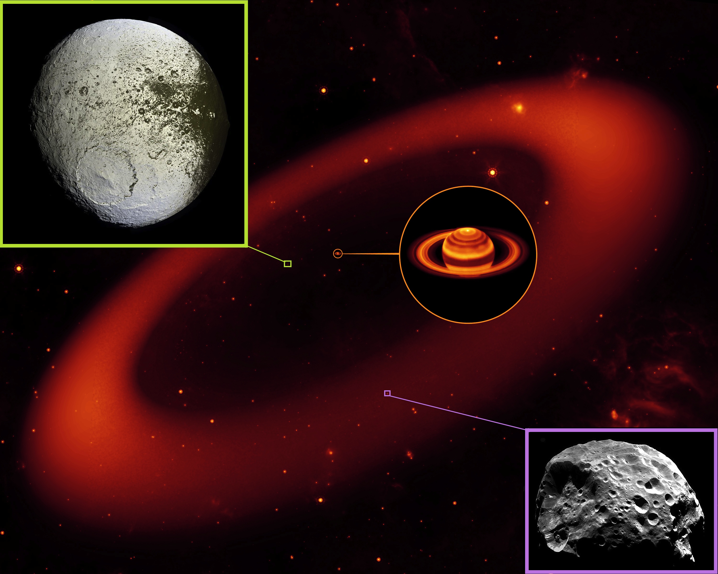 Saturn & the Phoebe Ring (middle) - NASA / JPL-Caltech / Keck; Iapetus (top left) - NASA / JPL / Space Science Institute / Cassini Imaging Team; Phoebe (bottom right) - NASA / ESA / JPL / Space Science Institute / Cassini Imaging Team.
March 1, 2014
Old Tool, New Use: GPS and the Terrestrial Reference Frame
by Alex H. Kasprak
Flying over 1300 kilometers above Earth, the Jason 2 satellite knows its distance from the ocean down to a matter of centimeters, allowing for the creation of detailed maps of the ocean's surface. This information is invaluable to oceanographers and climate scientists. By understanding the ocean's complex topography - its barely perceptible hills and troughs - these scientists can monitor the pace of sea level rise, unravel the intricacies of ocean currents, and project the effects of future climate change.
But these measurements would be useless if there were not some frame of reference to put them in context. A terrestrial reference frame, ratified by an international group of scientists, serves that purpose. "It's a lot like air," says JPL scientist Jan Weiss. "It's all around us and is vitally important, but people don't really think about it." Creating such a frame of reference is more of a challenge than you might think, though. No point on the surface of Earth is truly fixed.
To create a terrestrial reference frame, you need to know the distance between as many points as possible. Two methods help achieve that goal. Very-long baseline interferometry uses multiple radio antennas to monitor the signal from something very far away in space, like a quasar. The distance between the antennas can be calculated based on tiny changes in the time it takes the signal to reach them. Satellite laser ranging, the second method, bounces lasers off of satellites and measures the two-way travel time to calculate distance between ground stations.
Weiss and his colleagues would like to add a third method into the mix - GPS. At the moment, GPS measurements are used only to tie together the points created by very long baseline interferometry and satellite laser ranging together, not to directly calculate a terrestrial reference frame.
"There hasn't been a whole lot of serious effort to include GPS directly," says Weiss. His goal is to show that GPS can be used to create a terrestrial reference frame on its own. "The thing about GPS that's different from very-long baseline interferometry and satellite laser ranging is that you don't need complex and expensive infrastructure and can deploy many stations all around the world."
Feeding GPS data directly into the calculation of a terrestrial reference frame could lead to an even more accurate and cost effective way to reference points geospatially. This could be good news for missions like Jason 2. Slight errors in the terrestrial reference frame can create significant errors where precise measurements are required. GPS stations could prove to be a vital and untapped resource in the quest to create the most accurate terrestrial reference frame possible. "The thing about GPS," says Weiss, "is that you are just so data rich when compared to these other techniques."
You can learn more about NASA's efforts to create an accurate terrestrial reference frame here: http://space-geodesy.nasa.gov/.
Kids can learn all about GPS by visiting http://spaceplace.nasa.gov/gps and watching a fun animation about finding pizza here: http://spaceplace.nasa.gov/gps-pizza.
This article was provided by the Jet Propulsion Laboratory, California Institute of Technology, under a contract with the National Aeronautics and Space Administration.
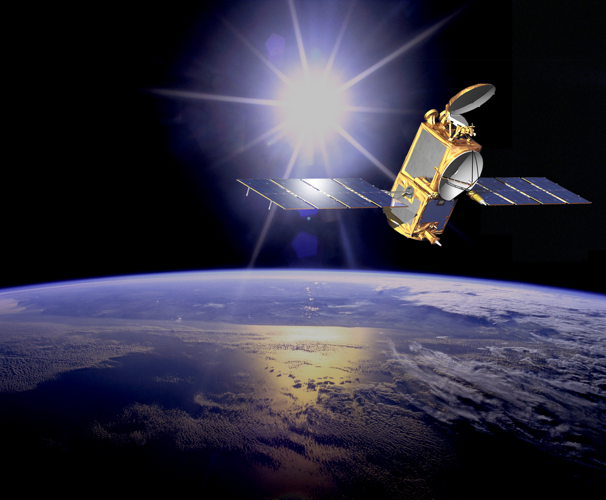 Artist's interpretation of the Jason 2 satellite. To do its job properly, satellites like Jason 2 require as accurate a terrestrial reference frame as possible. Image courtesy: NASA/JPL-Caltech.